Story of Ashab ul Kahf seven sleepers of cave

Cave of Ashabe-Kahf 

Exterior of the Cave of the Ashabe-Kahf

This is regarded as the cave in which a group of pious youths (equated with the Christian legend of the ‘Sleepers of Ephesus’) sought refuge from a tyrannical pagan king and in which Allah (ﷻ) caused them to sleep for 300 years. Their story is mentioned in the Holy Quran in Surah Kahf. The cave is located in the suburb of Abu Alanda in Amman.

  • In around 250 CE there ruled a Roman king called Daqyanoos (Decius) who would annually hold a gathering dedicated to the worshipping of idols. Many people would attend, dressed in their best clothing. However, one youth believed in the oneness of Allah (ﷻ), the teachings of Isa (upon him be peace) and shunned pagan worship. He rebelled against the practices that were happening in the society. He attracted another youth and then another to form a small group.

Sign for the Cave of the Ashabe-Kahf

  • When the king heard of their rebellion he became very angry and issued a command for them to be killed. In order to save their iman (faith) they fled and went into hiding. On their escape route they met a young farmer who owned a dog; they gave him da’wah, he accepted and decided to also join them. Eventually they came to a cave in which they made dua to Allah (ﷻ) for ease. They decided to take rest there for a while, leaving the dog (named Qitmir) near the entrance as a guard. Allah (ﷻ) caused them and the dog to sleep for 300 years.

Close up of the entrance to the Ashabe-Kahf cave

  • Allah (ﷻ) describes their sleeping in the Holy Quran in Surah Kahf:
    “And thou wouldst have deemed them waking though they were asleep, and we caused them to turn over to the right and the left, and their dog stretching out his paws on the threshold. If thou hadst observed them closely thou hadst assuredly turned away from them in flight, and hadst been filled with awe of them.” [18:18]
  • The Quran further states that the period of time these sleepers spent in the cave was 300 years during which the calendar of their people was changed from solar to lunar and, as a result, the period of their sleep was 309 years. When they woke up, they had no idea they slept for centuries and thought they had only slept a few hours. When they sent one of them to buy food, the shopkeeper was amazed to see such old coins and the reality of the time they had spent in the cave gradually came to light. The present ruling king, whom some scholars have identified as Tandoosees, was a believer who came on foot to see them and seek their blessings. When these young men died they were buried in the cave along with their dog. The bones of these youth and the dog are visible to see inside.
  • Apart from Amman in Jordan, the location of the cave is also claimed to be in Turkey. And Allah (ﷻ) knows best.

View from the top of the Cave of the Ashabe-Kahf

  • To the left of the entrance is an ancient olive tree. At one time a small church was built on top of the cave; this was converted to a mosque with the mihrab still being visible above the entrance.
Advertisement

A New Arabic Text of Mechanics: Sinan ibn Thabit on the Theory of Simple Machines

The Arabic manuscript Orient fol. 3306 preserved at the Staatsbibliothek in Berlin was in its original form a precious collection of Arabic scientific texts of mechanics and optics. It contains a fragment in one folio page consisting in a brief characterisation of the five simple machines: lever, windlass, pulley, wedge, and screw. This short text and is attributed to Sinān ibn Thābit, the son of Thābit ibn Qurra and a known mathematician and physician in Baghdad during the 10th century. It is a new source that has never been studied before. In the following article, we present the Arabic text of Sinan ibn Thabit and its English translation, accompanied with historical and analytical commentaries.

by Mohammed Abattouy[1]

The Arabic manuscript Orient fol. 3306 preserved at the Staatsbibliothek in Berlin[2] was in its original form a precious collection of Arabic scientific texts of mechanics, containing also two tracts on optics. The original content of the manuscript is given on the first page of the codex. Among the texts listed on this page we find the following title: Multaqatāt Kitāb al-tām li-Sinān b. Thābit fī dhikr ’uṣūl al-khamsa (sic) (Extracts from the Complete Book by Sinān b. Thābit in the mention of the principles of the five [simple machines]). This title corresponds to a fragment in one folio page in the codex, namely the folio 132r-v (fig. 1a-b). The recto page of the folio consists in a brief characterisation of the five simple machines, the “five powers” of the Ancients (lever, windlass, pulley, wedge, and screw), while we find on the verso the description of various other machines. It appears that these two fragments were extracted from a longer text entitled originally Al-kitāb al-tām (the Complete Book) by Sinān ibn Thābit. Obviously, this scholar is the son of the well known scientist Thābit ibn Qurra, and he was himself a mathematician and physician in Baghdad during the 10th century.

The fragment attributed to Sinān ibn Thābit on simple machines conserved in the MS 3306 is a completely new source that has never been studied before. In the following, the Arabic text and its English translation are presented, with historical and analytical commentaries, including a bio-bibliography of Sinān ibn Thābit.


Fig. 1 (a-b): The title of Sinān’s text on the first page of MS 3306 and the first line of the text on the top of folio 132r.

1. Description of MS 3306 and its contents

As it is attested by a note written on its first folio, the materials conserved in the MS Orient fol. 3306 of the Berliner Staatsbibliothek (State Library of Berlin) were copied or bound in one volume in 1090 H (1679). These materials form a collection of texts of physics (mainly mechanics and optics) of which the list is given on the first page of the codex. This collection contains 10 titles in the following order.

  • Risālat al-Jazarī fī a‛māl al-hiyal (Treatise of Al-Jazarī on the construction of machines).
  • Multaqaṭāt Kitāb al-tām li-Sinān b. Thābit fī dhikr uṣūl al-khamsa (sic) (Extracts from the Complete Book by Sinān ibn Thābit on the five powers).
  • Maqālat al-Khāzinī fī a‛māl al-kura tadūr bi-dhātiha (sic) (Treatise of Al-Khāzinī on the construction of a sphere that rotates by itself).
  • Sharḥ kitāb Biyanius (?) al-ḥakīm fī ṣan‛at marāyā al-muḥriqa (sic) (Commentary on the book of Biyanius (?) the sage on the art of burning mirrors).
  • Risāla fī … li-ma‛rifat al-ṣā‛a wa-anwā‛ al-rukhāma wa-ghayruhu (Treatise on … for the determination of the hour and different types of plates).
  • Kitāb Uqlīdīs al-ḥakīm fī ‛ilm al-manāẓir wa-kayfiyyāt al-shu‛ā‛ (The book of Euclid in the science of optics and the theory of rays).
  • Risāla fī ‛amal anwā‛ al-dawālīb al-mudawwara min tilqā’ dhātihā (Treatise on the construction of [various] types of wheels that move by themselves).
  • Fawā’id fī ma‛rifat mīzān al-‛adl wa ghayruhu (Utilities concerning the balance of justice and other things).[3]

Among these titles, only two are conserved in the volume as it is preserved at present in Berlin’s Staatsbibliothek: a complete copy of the text of Al-Jazarī on machines in 132 folios, accompanied with beautiful drawings in colour, marked by a good artistic quality, and two fragments from the text attributed to Sinān ibn Thābit. These two fragments are written on the folio 132 recto-verso. This folio is inserted at the end of Al-Jazarī’s treatise. Obviously, this folio 132 is part of a longer text on mechanics, but unfortunately this is the only surviving part. That the folio was originally part of a longer text is indicated by the fluent and normal course of discourse at the end of folio 132v and the way the last word (’imtalā’) is written, below the last line, so as to provide a reference to the first word on the next folio, which is no longer extant in the codex.[4]

The two faces of folio 132 include the following materials. The recto displays a theory of simple machines that will be dealt with in the rest of this article. The verso contains descriptions of several mechanical devices (fig. 2a-b). The latter are referred to by a sentence which looks like a header (it is written in bold): “hādhihi uṣūl mukhtalifa min uṣūl al-ḥiyal” (these are various basic machines). Then begins the description of a machine: unbūb ka’s al-‛adl (the pipe of the cup of justice). At the end of the description, the author states that this device was described in full in “Al-Kitāb al-tām alladhī minhu ikhtaṣartu hādhā” (the Complete Book from which I summarized this [extract]).[5]

   
Fig. 2(a-b): Folio 132 recto and folio 132 verso. The first containing the text of Multaqaṭāt Kitāb al-tām li-Sinān b. Thābit fī dhikr uṣūl al-khamsa, whilst the second includes the description of various machines (’uṣūl al-ḥiyal), being part of Sinān ibn Thābit’s original treatise.

On the basis of the available data, it is possible to reconstruct the genesis of this text along three stages:

(1) First, Sinān ibn Thābit composed a book known as Al-Kitāb al-tām, of which at least a part is devoted to mechanical issues. Given the title of the book, we can suppose that the treatise has an encyclopaedic scope, and hence was conceived as a treatise on mathematical sciences in which a part deals with mechanics, including the theory of simple machines and the description of a series of simple devices.

(2) At least the section of Al-Kitāb al-tām devoted to the theory of simple machines was summarized (ikhtiṣār), probably by the author, namely Sinān ibn Thābit, but it is possible that this summary was achieved by another scholar.

(3) The fragment that survived on folio 132 in MS Berlin 3006 in its present form is an extract (multaqaṭāt) from this summary; as it was said above, such an extract may have been composed by another scholar than the author of the book. Several indications attest that the two pages of folio 132 are part of a longer text. The exceptional status of this folio 132 is that it represents the only surviving evidence known so far of Sinān’s Al-Kitāb al-tām and the unique source we know of mentioning his interest for mechanics.

The last folio of MS Berlin 3306, namely folio 133, includes the last two pages of al-Jazarī’s treatise. On the recto, we find a part of Al-Jazarī’s text about a machine “zawraq fīhi malāḥ wa-fīhi zammāra” (a boat with a sailor and a flute). Then begins the colophon of Al-Jazarī’s treatise preceded by the list of letters in abjadsystem used in the treatise (21 letters of the Arabic alphabet) and the symbols to which they correspond in the book. This means that originally the copy of Al-Jazarī’s work preserved in MS 3306 was complete.[6]

In the list of the contents of MS Berlin 3306 as well as in the title of the text on simple machines, the fragment in folio 132 is attributed to Sinān ibn Thābit. That the author of this text is Sinān ibn Thābit, the son of Thābit ibn Qurra, is supported by different arguments. First of all, the text is ascribed in the manuscript to Sinān ibn Thābit, identified as the son of Thābit ibn Qurra by the editors of the German catalogue where MS 3306 is mentioned.[7] Furthermore, several indications attest that the fragment is of an early date and may have been written by Sinān in the first half of the 10th century. This is confirmed by the archaic style of the vocabulary, as it is shown by the following two significant instances: the lever is called muḥl; later on, the standard word for it was bārim or bayram; the same for qarasṭūn (= steelyard), transformed later on as qaffān and qabbān.[8]

On the other hand, as far as we know, there exists no scholar in the Islamic scholarship bearing the name Sinān ibn Thābit, but Abū Sa‛īd, the son of Thābit ibn Qurra. In addition, the text is bound with several early Arabic writings that still reflect traces of the Graeco-Arabic transmission period, as it is clearly shown in the table of contents of the codex. Nevertheless, no historical source ever mentioned a writing of Sinān ibn Thābit in mechanics, although this should not be considered a priori as a counter-argument to deny the possible existence of such an interest. The ongoing investigation on the corpus of Arabic mechanics and engineering and its achievements is changing; new discoveries were made and others are still to come. This has been proved in the field of theoretical mechanics, with the dramatic change generated by the recent research on the science of weight (‛ilm al-athqāl).[9]

The MS Berlin 3306 was published online on the website of the Max Planck Institute for the History of Science in Berlin, as a result of the investigation performed by the author of this article on this document in the Staatsbibliothek in Berlin. This electronic edition may be accessed here: Anonymus, Ms. or. fol. 3306, Arabisches manuscript.

2. Bio-bibliography of Sinān ibn Thābit 

Abū Sa‛īd Sinān ibn Thābit ibn Qurra al-Ḥarrānī is a well known scholar of the 10th century. He is mentioned in the classical and modern sources as a mathematician, astronomer, physician and historian. He was the son of Thābit ibn Qurra (d. 288 H/ 901), the famous Harranian scholar who flourished in Baghdad and excelled in different fields of science and medicine, including mathematics, astronomy and mechanics. Two sons of Abū Sa‛īd Sinān ibn Thābit distinguished themselves in science and medicine. The first one, Abū Isḥāq Ibrāhīm ibn Sinān, was a genius mathematician. He left valuable works, such as his famous treatise on analysis and synthesis. He died in Baghdad in 335 H/946-947 when he was only 38 years old.[10] The second one is Abū ‘l-Ḥasan Thābit b. Sinān (b. Thābit b. Qurra) who excelled in medicine and died in 363 H/973-73.[11]

Sinān ibn Thābit was the personal physician of two Abbasid Caliphs, Al-Muqtadir (r. 908-932) and Al-Qāhir (r. 932-934). He served also Al-Rādhī (934-940), with whom he entertained good relationships. The latter asked him to convert to Islam, but Sinān was not ready to embrace Islam and change his religion. Being afraid to disobey the Caliph’s request, he fled to Khurasan. He came back to Baghdad after the destitution of Al-Qāhir. But later on, he converted to Islam and died in Baghdad as a Muslim at the beginning of Dhū-‘l-qi‛da 331 H (August 943).[12]

Sinān ibn Thābit was the representative of the second generation of Harranian scientists and physicians in the Abbasid court in Baghdad, in the aftermath of the arrival and settlement of his father Thābit ibn Qurra in the Abbasids’ capital in the middle of the 9th century. By converting to Islam, he put an end to the Sabian tradition of the prestigious family his father had founded in the capital of the Muslim empire, and strengthened its integration in the Muslim society. For a long time before and after him, scholars originating from Harran occupied eminent positions among the intellectual, scientific and medical elite at the caliphal court and in the high spheres of society.

Ibn abī ’Uṣaybi‛a mentioned that Abū Sa‛īd Sinān ibn Thābit was well versed in the sciences like his father, and he was gifted in astronomy and in the art of medicine. He described in detail the efforts deployed by Sinān ibn Thābit in the organisation of hospitals and enumerated the moral qualities of Sinān, such as his commitment under Al-Muqtadir to provide medical care to prisoners in Baghdad and to poor people in the suburbs of the city.[13]

Besides his distinction in medicine and astronomy, Sinān was also a historian and a gifted mathematician. Ibn al-Nadīm ascribed to him two texts in mathematics: Kitāb fī ‘l-istiwā‛ (Book of levelling), and Iṣlāḥuhu li-kitāb (…)[14] fī al-‛uṣul al-handasiyya, wa zāda fī hādhā al-kitāb shay‛an kathīran (his revision/edition of The Book… of Geometrical Principles, to which he added a great deal). Later on, Ibn al-Qiftī provides the full title of this book and states that this treatise of ’uṣūl handasiyya that Sinān ibn Thābit edited and augmented was the work of A/Iflāṭun (Plato?).[15] It is possible to conjecture that this book of ‘uṣūl‘ worked out by Sinān ibn Thābit was a book of mathematical sciences in which our scholar enriched a Greek original text, and added one or more chapter, one of them dealing with mechanics. In this case, this book should bear in certain copies the name of Al-Kitāb al-tām, from which the fragment of ‘’uṣūl‘ on simple machines was extracted. However, no evidence is available to support such a conjecture, and one is bound to suppose that al-Kitāb al-tām stands as an independent writing of Sinān, even though none of his bio-bibliographers made any mention of it.

Other works of mathematics are attributed to Sinān ibn Thābit, such as his edition of a text of Archimedes on the triangles,  translated previously by Yūsuf al-Qiss from Syriac.[16] The bio-bibliographers mention also that he performed the revision of the works of the mathematician al-Kūhī (Iṣlāḥuhu li-‛ibārat Abī Sahl al-Kūhī fī jamī‛i kutubihi). The fact that al-Kūhī asked Sinān to revise his writings is a sign of competence and recognition of his abilities, and testifies to the privileged relationships between the two scholars. Given what we know of Sinān’s work, we can suppose that the revision went far beyond the linguistic and stylistic presentation of the texts to reach certain aspects of the contents. [17]

3. Survey of the Arabic tradition of the five simple machines 

As far as we know, no historical source mentioned that Sinān ibn Thābit wrote a text of mechanics titled Al-Kitāb al-tām nor reported about his interest in mechanics. Thus, the material preserved in Codex Berlin 3306 and ascribed to this author is a new and unknown component of the Arabic corpus of mechanics, and one of the rare Arabic writings on the theory of simple machines or the five powers. This theory was directly inspired from Greek works translated into Arabic, such as the mechanical treatises of Pseudo-Aristotle, Heron and Pappus. Besides Sinān ibn Thābit’s fragment, the main treatises which we know of today as having developed the theory of the five simple machines in Arabic mechanics are: Mi‛yār al-‛uqūl, a Persian treatise attributed to Ibn Sīnā and Al-Isfizārī’s summary of the second book of Heron’s Mechanics.

Mi‛yār al-‛uqūl dur fan jar athqāl (The Measure of mind or the art of dragging weights) is a Persian treatise attributed to Abū ‛Alī al-Ḥusayn ibn Sīnā (980-1037). It deals with the description of the five simple machines and of their use in displacing heavy loads. As such, the text is a precious source for the reconstruction of the theory of the five powers in Islamic science in the 10th and 11th centuries. Mi‛yār al-‛uqūl is not just a mere summary of the Greek theory of simple machines as it was transmitted in Hellenistic sources. It represents the first systematic classification of those machines, individually and in combination.[18]

Mi‛yār al-‛uqūl describes the five simple machines in four chapters. In the first two chapters, the author follows closely Heron’s characterization of the five powers, and borrows the essential part of his descriptions and drawings of the simple machines from Heron’s Mechanics. The machines are quoted in this order: miḥwar(windlass), muḥl (lever), bakara (pulley, wheel), lawlab (screw) and isfīn (wedge).[19] The description of each machine is accompanied by a diagram and illustrated by a geometrical figure. The second part of the treatise, composed of chapters 3 and 4, contains descriptions of combinations of the five simple machines. Like Heron, ibn Sīnā classifies these combinations by the principle of likeness or unlikeness of the constituent five powers. Thus, in chapter 3, he describes combinations of like simple machines: windlasses, pulleys and levers. Then, in chapter 4, he goes beyond the limits of Heron’s classification when he successively analyses all probable combinations and considers all practically probable pair wise combinations of unlike simple machines: windlass-pulley, windlass-lever, windlass-screw. Finally, in chapter 4-section 5, he describes a mechanism which is essentially a combination of four simple machines; only the wedge is left apart (fig. 3a-b).


Fig. 3 (a-b): The five simple machines of the ancients, plus the “inclined plane”, a device to which modern mechanicians reduced the wedge and the screw. Adapted from Unit 3: Simple machines, p. 2.

Another work in the Islamic tradition on simple machines is contained in Al-Isfizārī’s epitome of the second book of Heron’s Mechanics. This summarized version exists in two known manuscript sources: MS 351 at the John Rylands Library in Manchester (UK) and MS Q‛620 H-G at the ‛Uthmāniyya University Library in Hyderabad (India). Composed of a series of epitomes and commentaries on selected parts of the mechanical works of Heron, Apollonius and Banū Mūsā, this text has never been studied nor edited and was mentioned so far only in some studies by the author of this article (fig. 4).[20]


Fig. 4 (a-b): The five simple machines in the Arabic version of Heron’s Mechanics: (1) the windlass, (2) the lever, (3) the wedge, (4) the pulley and (5) the screw. Source: Andhra Pradesh Government Oriental Manuscripts Library and Research Institute in Hyderabad, MS Riyādhī 396, respectively on folios 14v, 15v, and 16r.


4. The Arabic text and English translation 

In the following, a transcription of the text of Sinān’s fragment is provided, with English translation. It should be pointed out that because of difficulties in reading some words of the last paragraph in the manuscript; the transcription proposed hereinafter for the last lines of the text is tentative only, until we have access to this fragment in another manuscript source.

On the other hand, as it may be seen on figure 5, the last part of the text is written in four lines on the left hand margin of the page. This may be due to the desire of the copyist to include all the text of Sinān’s treatment of the theory of simple machines on the same page (perhaps for better reading).


Fig. 5: Facsimile of the folio page 132r of Sinān ibn Thābit’s fragment on simple machines in MS 3306. Source: The Staatsbibliothek in Berlin, electronic edition, Anonym., Ms. or. fol. 3306 – Arabisches manuscript.

Multaqatā [min al-]Kitāb al-tām li-Sinān ibn Thābit fī dhikr al-uṣūl al-khamsa

 Extracts from the Complete Book by Sinān ibn Thābit on the Five Powers

These are basic principles of the art of mechanics extracted from a book which has been summarized by Sinān ibn Thābit from his book called The Complete Book.

هذه أصول لصناعة الحيل ملتقطة من كتاب قد اختصره سنان بن ثابت من كتابه الموسوم بالكتاب التام.

These are five basic [machines], and their names are: the axle introduced in a wheel [the windlass], the lever, the pulley, the wedge and the screw.

وهي أصول خمسة وألقابها هذه: المحور الداخل في فلكة، المحل، الآلة الكثيرة الرفع، الأجنة،[21] اللولب.

The axle introduced in a wheel: Its description: you take a round axle of which the middle or any other part has been squared, and it is introduced in a wheel as the axle of the cart-wheel is introduced in its wheel.

المحور الداخل في فلكة: صفته أن تتخذ محور مدور قد رُبِّع وسطه أو موضع آخر منه فيدخل في بكرة كما يدخل محور العجل في بكرتها الداخل في فلكة.

But the hole of the wheel in which the axle is introduced is made squared also, fitting on the squared part of the axle. The wheel must have teeth/cogs. This is its description.

إلا أنه يجعل ثقب البكرة الذي فيه يدخل المحور مربعا أيضا متهندم على الموضع الذي ربع من المحور والبكرة تكون ذات دندانجات، فهذه صفته.

As for the utility drawn from it, it is [used] for raising heavy things and in all what requires the multiplication of force, so that the force of one single man may do what can be done definitely by several men only, and this either in throwing or in pulling or otherwise.

وأما الإنتفاع به فيكون في رفع الأشياء الثقيلة وفي سائر ما يحتاج فيه إلى أن تضاعف القوة، فيعمل بقوة رجل واحد ما لا يعمله على الإطلاق إلا عدة رجال، كان ذلك في رمي أو في جذب أو في غيرهما.

The method to raise a heavy thing with it is that a spoke is spoked in a place of the axle and to which is fastened the rope by which the weight is suspended. When the wheel revolves, it is pulled by its cogs or by another wheel with the cogs of which its cogs are entangled.

وأما الوجه في رفع شيء ثقيل به بأن يوتـّـد في موضع من المحور وتد يشدّ به الحبل المعلق به الثقل، فإذا أديرت البكرة تجذب الأسنان إياها بدندانجاتها أو ببكرة أخرى تشابك دندانجاتها دندانجات هذه.

The lever: There is no difference between it and the steelyard (qarastūn) in its theory. It is the principle to which most of the matter of heaviness and lightness is reduced.

المحل: لا فرق بينه وبين القرسطون في حكمه، وهو الأصل الذي إليه يرجع أكثر أمر الثقل والخفة.

The lever is this instrument used by the carpenters which is called al-bārim. It is called in some books of mechanics al-qārūs. The instrument used by sailors known as al-jālis is this one.

والمحل هو هذه الآلة التي للنجارين تسمى البارم، وقد سمي في بعض كتب الحيل القاروص. والآلة التي للملاحين المعروفة بالجالس[22] هي هذه.

[The beginning of the paragraph on the pulley is missing]

The description of this instrument is that we take two hard and solid wooden plates. We dig in each one of them at several places and we set at each place a wheel which turns therein on an axle. The number of wheels in one of them should equal those in the other. We suspend one of the plates above the position to which we want to raise the weight and [we attach] the other to the weight which we want to raise.

[…]

وصفة هذه الآلة أن تؤخذ خشبتين صلبتين وثيقتين فنحفر في كل واحدة منها عدة مواضع ونركب في كل موضع منها بكرة تدور فيه على محور. ويكون عدد البكر في أحديها مثل عدده في الأخرى. ونعلق أحديهما فوق الموضع الذي إليه نريد أن نرفع الثقل، والأخرى في الثقل الذي نريد رفعه.

Then we take a long rope and we grasp one of its ends so that the weight may be pulled by it. We introduce the other end in one of the wheels attached to the higher plate. We lower it and revolve it around one of the wheels attached to the lower plate. We lift it and revolve it on the second wheel attached to the higher plate. We lower it and revolve it on the second wheel attached to the lower plate.

ونأخذ حبلا طويلا فيمسك أحد طرفيه ليجذب به الثقل فيدخل الطرف الآخر في إحدى البكر التي في الخشبة العليا، ونحدره فنديره على بكرة من التي في الخشبة السفلى، ونصعده فنديره على البكرة الثانية من الخشبة العليا ونحدره فنديره على البكرة الثانية من الخشبة السفلى.

We keep repeating this according to the ratio of the weight we want to raise to the pulling force. Then we fasten the end of the rope that we have revolved to one of the wheels, be it one of the highers or one of the lowers. We have then four proportional magnitudes:

ولا نزال نكرر ذلك على حسب نسبة الثقل الذي نريد رفعه إلى القوة الجاذبة. فنشد حينئذ طرف الحبل الذي أدرناه عند بعض البكر، إن شئنا العليا أو السفلى، فتكون لنا في هذا أيضا أربعة مقادير متناسبة:

The ratio of the number of wheels, which is also the number of revolutions of the rope, to one is as the ratio of the raised weight to the weight raising it without the intermediary of the force pulling it. If three of them are known and one is unknown, whatever it is, we may know its magnitude and determine it by the method of the four proportional numbers.

نسبة عدد البكر وهو عدد دورات الحبل إلى الواحد كنسبة الثقل الذي رفع إلى الثقل الذي يرفعه بغير حيلة القوة الجاذبة له. فإذا كان ثلاثة منها معلومة وواحد مجهول أي واحد كان عرفنا مقداره واستخرجناها بطريق الأربعة الأعداد المتناسبة.

The screw: If it is said absolutely, the screw means a rounded [piece of] wood on which a screwed line (khaṭ lawlabī) is marked. It may be composed of a pipe which occupies its length in whole or in part.

اللولب: إذا قالوا اللولب مطلقا فإنما يذهبون إلى عود مدور مخطوط عليه خط لولبي وقد يتهيأ أن يكون مركبا من أنبوبة إما أن تأخذ طوله كله وإما بعضه.

But it has inside a screwed line corresponding to this line so that when the pipe is kept fixed while the screw is revolved, it goes in and out. If it is revolved and prevented from going in and out, it enters in the pipe…[23] With the condition that the screw is set on a plane circle so that the… [24]

إلا أن في داخلها خط لولبي يطابق هذا الخط فيكون إن ثبتت الأنبوبة وأدير اللولب دخل وخرج. وإن أدير ومنع[25] من الخروج والدخول دخل إلى الأنبوبة وخرج،[26] هذا إن كان/وذلك أن يكون اللولب مركبا على دائرة مشرحة فيكون المدبب (؟) فيه.

It occurs in this instrument, I mean the screw, a motion composed of two motions, the circular motion and the straightforward motion. In the screw having closer lines (al-mutaqārib al-khuṭūṭ) the circular motion dominates (aghlab) and its rotation is easier. Hence the weight it raises is greater and the time of its lifting is longer.

وهذه الآلة أعني اللولب تعرض منها حركة مؤلفة من حركتين حركة الإستدارة وحركة الإستقامة. واللولب المتقارب الخطوط حركة الإستدارة فيه أغلب وإدارته أسهل فالثقل الذي يرفعه أعظم وزمان إرتفاعه أطول.

In the screw having wider lines the motion of straightness dominates, and it acts contrarily to the one having closer lines, with respect to the magnitude of what it raises, to the time in which it raises it and in every other circumstance. It is by these two motions that we mark the screwed line.

واللولب المتباعد الخطوط فالإستقامة في حركته أغلب وهو في مقدار ما يرفع وفي الزمان الذي يرفعه فيه وفي سائر الأحوال على ضد ما عليه المتقارب الخطوط وبهاتين الحركتين نخط الخط اللولبي.

The wedge

الأجنة[27] [الإسفين]

Its utility is in the matter of mechanics (’amr al-ḥiyal) and it is very rarely used [outside of it]. It acts in one exclusive place where it does a wonderful action can not be replaced[28] by anything else amongst the rest of the five powers (al-khams uṣul)[29], namely in cutting and extracting stones (qatc… qalc), and in sum in splitting (shaq) everything that may be splitted…[30]

فالإنتفاع به في أمر الحيل وإستعماله قليل جدا وله موضع واحد يفعل فيه فعلا عجيبا ولا مناص منه فيه ولا ينوب عنه شيء من باقي الخمس أصول، وهو قطع الحجارة وقلعها، وبالجملة شق كل شيء يشق. وكانوا ربما إستعملوه في سور المدينة أو في الحفر ومايشابهه…[31]

5. Short analysis of the contents of the text 

Sinān ibn Thābit’s text presents a summarized theory of the five simple machines in the form of short descriptions of their functions. The machines are identified on the basis of two procedures: terminological meaning of their names and practical considerations on their use.

The five simple machines dealt with are: the windlass, the lever, the pulley, the screw and the wedge. These machines are called by the same Arabic terms employed in the translation of the Greek names of these instruments. The only difference is the name given to the wedge. Instead of the usual Arabic term used for this instrument, which is al-isfīn, it is called in MS 3306 as al-ajanan, probably an Arabization of its name in Greek, Syriac or Persian (fig. 6).


Fig. 6: Table of the Arabic names of the simple machines in translated Greek sources and in Arabic texts.

The order in which the simple machines are quoted in the major sources that discussed the theory of simple machines in Greek and Arabic mechanics seem to be Book II of Heron’s Mechanics. The only exception is the Mi‛yār al-‛uqūl ascribed to Ibn Sīnā, where the wedge is dealt with before the screw. For comparison, the simple machines are quoted in Pseudo-Aristotle’s Mechanical Problems in the following relative order: the lever, the windlass, the wedge and the pulley, the lever being considered the basic machine to which all other simple machines are to be reduced, especially the windlass and the pulley.

The fact that the lever is not quoted in the first place in Sinān’s text may testify an inclination to discard the Peripatetic view which consists in the reduction of all the simple machines to the lever, and thus to the circular motion it represents. On the other hand, Sinān ibn Thābit’s text establishes a clear connection between the lever and the steelyard, referred to as qarasṭūn, the name of Greek origin that prevailed for this instrument in Arabic scientific literature in the 9th and 10th century. Thābit ibn Qurra, the father of Sinān, wrote a very influential treatise on it under the title Kitāb fī ‘l-qarasṭūn.

The early date of Sinān’s text is attested by his vocabulary, which is reminiscent of the Arabic technical terminology derived from the translation of the Greek sources of mechanics. Hence, the steelyard is called qarasṭūn and not qabbān or qaffān (the last two terms are found in texts dating from the second half of the 11thcentury). Further, the lever is designated by muḥl and bārim. This synonymy denotes a transition between muḥl, directly derived from the Greek mochlos, and al-bayram, the standard Arabic word (of Persian origin) used by al-Khāzinī in Kitāb mīzān al-ḥikma (12th century). On the other hand, Al-Khwārizmī’s 10th-century text Mafātīḥ al-‛ulūm establishes an explicit synonymy between the two when it identifies mukhl (muḥl) and bayrambārim. In the same section, Sinān affords two other Arabic names for the lever: qāruṣ and jālis. As far as we know, these two terms are associated to the lever only in his text. In addition, the mention of two early and exotic terms for the lever (qārūs and jālis) denotes an early origin of the text, since these terms are not mentioned in any other later Arabic mechanical text.

Sinān’s description of the machines is similar to Heron’s nomenclature of these basic instruments, but with some refinements. This is the case of his description of the windlass. The characterization of the wedge as the only simple machine that cannot be replaced by any other one of the four other simple machines is identical in Heron and in Sinān. But the latter’s description of the lever is an admirable concentrated piece of theory. It establishes a direct analogy between this simple instrument and the steelyard. This analogy is reminiscent of a similar approach in Pseudo-Aristotle’s Mechanical Problems, even though Sinān’s remark that most of the problems of heaviness and lightness are to be referred to the properties of the lever goes beyond the limits of the analogy established in Pseudo-Aristotle between the lever and the balance. The son of Thābit ibn Qurra was more likely referring here to a well-established Arabic tradition of study of the steelyard in his time that made this instrument the model of the balance and of the other simple machines.

It is worthwhile to note that Sinān talks of the five simple machines in terms of ’aṣl (pl. ’uṣūl), meaning root, origin, and basic principle. In this perspective, Al-’usūl al-khams refer to the basic fundamental machines, on the basis of which other instruments may be conceived (they would be furū‛, consequences derived from them). This terminology is rooted in a usual dichotomy in Arabic thought, opposing ’uṣūl to furū‛, basic and primary things to consequences derived from them. In this context, the five powers are the basic machines from the combination of which other machines may be derived. Now the classification of machines and their combination is an important theme of Arabic mechanics, as for example in Mi‛yār al-‛uqūl attributed to Ibn Sīnā. It is thus possible that later sections in the complete version of Sinān ibn Thābit’s work were precisely devoted to the classification of machines and their combination.

Finally, two interesting terminological instances are to be specially noted in Sinān’s text. First, he used in the section about the pulley the word ḥīla in the sense of means, intermediary. This is exactly one of the original senses of mechane in Greek. Secondly, the idea of the composition of motion in the section on the screw is worth to be highlighted also. The working of this machine is said to be generated by two motions, a circular one and a straight one (ḥaraka mu’allafa min ḥarakatayn, ḥarakat al-istidāra wa-ḥarakat al-istiqāma). There is no such clear and explicit idea of the composition of motions in the screw in Heron’s discussion of this machine in the second book of his Mechanics.

6. Appendix: Description of the contents of MS 3306 

The list of the texts mentioned on the first page of MS 3306 contains ten items. It is presented in the following in three forms: facsimile reproduction, transcription (both in fig. 7a-b), and in English translation, with commentaries on the titles of the texts.


Fig. 7 (a-b): The first page of MS Berlin Staatsbibliothek 3306 and its transcription in Arabic.

English translation

“The books collected in this volume are:

  • Risālat al-Jazarī fī a‛māl al-ḥiyal (Treatise of Al-Jazarī on the construction of machines).
  • Multaqatāt Kitāb al-tām li-Sinān b. Thābit fī dhikr uṣūl al-khamsa (sic) (Extracts from the Complete Book by Sinān ibn Thābit on the five powers).
  • Maqālat al-Khāzinī fī a‛māl al-kura tadūr bi-dhātiha (sic) (Treatise of Al-Khāzinī on the construction of a sphere that rotates by itself).
  • Sharḥ kitāb Biyanius (?) al-ḥakīm fī ṣan‛at marāyā al-muḥriqa (sic) (Commentary on the book of Biyanius (?) the sage on the art of burning mirrors).
  • Risāla fī … li-ma‛rifat al-sā‛a wa anwā‛ al-rukhāma wa-ghayruhu (Treatise on… for the determination of the hour and different types of plates).
  • Kitāb Uqlīdīs al-ḥakīm fī ‛ilm al-manāẓir wa-kayfiyyāt al-shu‛ā‛ (The book of Euclid in the science of optics and the theory of rays).
  • Risāla fī ‛amal anwā‛ al-dawālīb al-mudawwara min tilqā’ dhātihā (Treatise on the construction of [various] types of wheels that move by themselves).
  • Fawā’id fī ma‛rifat mīzān al-‛adl wa-ghayruhu (Utilities concerning the balance of justice and other things).

Commentaries on the titles

1. (Risālat al-Jazarī fī a‛māl al-ḥiyal (Treatise of al-Jazarī on the construction/making of machines): this is a complete copy of Al-Jāmi‛ bayna al-‛ilm wa al-‛amal al-nāfi‛ fī ṣinā‛at al-ḥiyal, the well-known work of Al-Jazarī (completed in 1206). This manuscript copy was not used in the recent edition and translation of al-Jazarī’s treatise.[32] It occupies ff. 1b-131b and f. 133a-b. The short text of one folio of Sinān ibn Thābit is intercalated at its end on f. 132r-b.

2. Multaqatāt Kitāb al-tām (sic) li-Sinān b. Thābit fī dhikr uṣūl al-khamsa (sic) (Extracts from The Complete Book of Sinān ibn Thābit on the Five Powers): This short fragment is the subject matter of the present article.

3. Maqālat al-Khāzinī[33] fī ‛amal kura tadūr bi-dhātiha (Treatise of Al-Khāzinī on the construction of a sphere that rotates by itself): Abū ‘l-Fath ‛Abd al-Raḥmān al-Khāzinī flourished in Khurāsān around 1115- 31. The main domains of his scientific activity are astronomy, mechanics and scientific instruments. He is the author of the famous Kitāb mīzān al-ḥikma, the book of the balance of wisdom. His other known works include a treatise on astronom­ical instruments (Risāla fī ‘l-ālāt) and Maqāla fī itikhādh kura tadūr bi-dhātihā, the text on the sphere that rotates by itself mentioned in this entry in MS Berlin 3306 (fig. 8).

Fig. 8 : The drawing of Al-Khāzinī’s sphere. Source: Maqāla fī itikhādh kura tadūr bi-dhātihā, The Syrian National Library in Damascus, Al-Ẓahiriya Collection, MS 4871, folio 73r.

3. This text is known at present in two manuscript copies preserved respectively at the Syrian National Library in Damascus (al-Ẓahiriya Collection, MS 4871, ff. 73r-74r), and in the oriental collection at Oxford Library (MS Thurston 3, ff. 118-119r). It describes a celestial globe worked with weights. The instrument has the form of a solid sphere marked with the stars and the standard celestial circles and half sunk in a box. Its rotation is propelled by a weight falling in a leaking reservoir of sand. The sphere is mounted so as to rotate once a day. It functions like an automatic celestial instrument, and may be used to find directly several arcs of importance in spherical astronomy. [34]

4. Sharḥ kitāb Biyanius[35] (?) al-ḥakīm fī ṣan‛at marāyā (sic) al-muḥriqa (Commentary on the book of Biyanius (?) the wise on the construction of the burning mirrors): The name of the author – obviously a Greek scholar – is without diacritic marks. The text belongs to an established tradition of works translated from the Greek or composed in Arabic on burning mirrors.[36]

5. Risāla fī … li-ma‛rifat al-sā‛a wa anwā‛ al-rukhāma wa-ghayruhu (Treatise on … for the determination of the hour and the kinds of the rukhāma and other things): The text is on an astronomical instrument, a sort of gnomon for measuring time. Thābit ibn Qurra has written a text with a similar title: Kitāb fī ālāt al-sā‛āt allatī tusammā rukhāmāt (Book on the instruments which give the hours, called the solar quadrants (rukhāmāt).[37]

6. (Kitāb Uqlīdīs al-ḥakim fī ‛ilm al-manāẓir wa kayfiyyāt al-shu‛ā‛ (The Book of Euclid on the science of optics and the qualities of the ray). This text stems obviously from the tradition of the Arabic edition of Euclid’s Optics, but it bears a title completely different from all those occurring in the Arabic tradition. The title quoted in MS 3306 might be a very early instance of this Arabic tradition of Pseudo-Euclid’s Manāẓir. The reference it contains to the shu‛ā‛ (ray) constitutes a valuable reference to an important feature of this tradition, the Euclidean ray theory.[38]

7. Unreadable title.

8. (Risāla fī ‛amal anwa‛ al-dawālīb al-mudawwara min tilqā’ dhātihā (Treatise on the making of different wheels that turn by themselves): seems to deal with self-rotating wheels, a topic of Arabic mechanics to which several treatises are devoted. An important text of this category occurs in several manuscripts with the title: Bakarāt tadūr min dhātihā (or min tilqā’ dhātihā) (Wheels that move by themselves). It has usually been assumed that it is a discussion of perpetual motion and as such dismissed as of no practical significance. The descriptions are difficult to understand and the accompanying illustrations are obscure. Nevertheless, the machines appear to embody important mechanisms and they would certainly repay further detailed study.[39]

The affiliation between item 3 in MS 3306 and this text on perpetual motion can be established on the terminological basis: maḥāla and bakara are synonyms and they refer to the wheel. Furthermore, if this is established, this may give a clue to determine the author and the date of both works. The author of the former is indeed given as al-Khārijī, probably a deformation of the name of Muḥammad ibn al-Ḥusayn al-Karajī, a known mathematician of the 10th-11th century (d. ca. 1016). He is also author of a work on hidden waters (Kitāb inbāt al-miyyāh al-khafiyya).[40] This topic, connected with engineering and levelling, was considered traditionally as a branch of mechanics.

9.(Unreadable title).

10. Fawā’id fī ma‛rifat mīzān al-‛adl wa-ghayruhu: may be rendered as “Advantages/Utilities about the balance of justice”. It deals probably with a mechanical balance. The balance is considered basically in the Islamic tradition as an instrument of justice, as it is clearly stated by al-Khāzinī in his Kitāb mīzān al-ḥikma.[41]

7. References  

  • Abattouy, Mohammed 2000. “Al-Muẓaffar al-Isfizārī ‛ālim mikānīkī min al-qarnayn 5-6 H/11-12 M mu’allif Irshād dhawī al-‛irfan ilā ṣinā‛at al-qaffān” [al-Isfizārī a mechanician scholar from the 5-6 H/11-12 CE centuries, author of Guiding the Learned Men in the Art of the Steelyard]. In Quelques aspects de l’évolution des idées scientifiques. Antiquité et moyen âge. Rabat: Publications of the Faculty of Letters, pp. 135-175.
  • Abattouy, M. 2001. “Greek Mechanics in Arabic Context: Thābit ibn Qurra, al-Isfizārī and the Arabic Traditions of Aristotelian and Euclidean Mechanics.” Science in Context (Cambridge University Press) vol. 14: pp. 179-247.
  • Abattouy, M. 2006. “The Arabic Transformation of Mechanics: The Birth of the Science of Weights”. Published on www.MuslimHeritage.com in November 13, 2006. See the complete version of the article in PDF.
  • Abattouy, M. 2007a. “‛Abd al-Raḥmān al-Khāzinī.” The Biographical Encyclopaedia of Astronomers. Edited by par T. Hockey. Berlin/New York: Springer Verlag, pp. 629-630.
  • Abattouy, M. 2007b. “The Arabic Science of Weights (‘ilm al-Athqâl): Textual, Tradition and Significance in the History of Mechanics.” In A Shared Legacy, Islamic Science East and West“. Edited by E. Calvo, M. Comes, R. Puig and M. Rius. Barcelona : Universitat de Barcelona, 2008, 83-114.
  • Abattouy, M. 2011. “A New Arabic text of Mechanics: Sinan ibn Thabit on the Theory of Simple Machines”, in Studies on the History of Sciences, edited by Ja’far Aghayani Chavoshi, Tehran, 1390/2011, pp. 19-38.
  • Dold-Samplonius, Yvonne 1997. “Sinan ibn Thabit”. In Encyclopaedia of the History of Science, Technology, and Medicine in Non-Western Cultures, edited by Helaine Selin. Dordrecht/ Boston/ London: Kluwer Academic Publishers, p.902.
  • Euclid 1956. The Thirteen Books of Euclid’s Elements. Translated from the Text of Heiberg with Introduction and Commentary by Thomas L. Heath. New York: Dover, 3 vols.
  • Garbers, K. 1936. “Eine Werk Thabit ibn Qurra’s über ebene Sonnenuhren”. Quellen und Studien zur Geschichte der Mathematik, Astronomie und Physik, Abteilung A: Quellen, 4 (1936), pp. 1-80.
  • Hill, Donald R. 1974. The Book of Knowledge of Ingenious Mechanical Devices. An annotated translation of al-Jazarī’s Treatise. Dordrecht: Reidel.
  • Hill, D. R. 1991. “Arabic Mechanical Engineering: Survey of the Historical Sources.” Arabic Sciences and Philosophy 1: pp. 167-186.
  • Ibn abī ’Uṣaybi‛a, Muwaffaq al-Dīn 1965. ‛Uyūn al-anbā’ fī ṭabaqāt al-aṭibbā’. Edited by Niẓār Ridhā. Beirut: Dār maktabat al-ḥayāt.
  • Ibn al-Nadīm 1871-72. Kitāb al-Fihrist. 2 vols. Edited by Gustav Flügel, J. Roediger and A. Müller. Leipzig: F. C. W. Vogel.
  • Ibn al-Qifṭī 1903. Tārīkh al-ḥukamā’. Edited by Julius Lippert. Leipzig: Dieterich’sche Verlagsbuchhandlung.
  • Ibn Sīnā, Al-Shaykh al-Ra’īs abū ‛Alī [1952] 1331 (solar Persian calendar). Mi‛yār al-‛uqūl. Edited with introduction and notes by Jalāl al-Dīn Humā’ī. Tehran: Anjuman-i Athar-i Milli, n° 24.
  • Ibn Sinān, Ibrahim 1948. Rasā’il Ibn Sinān. Haydarabad: Maṭba‛at Jāmi‛at Dā’irat al-Ma‛ārif al-‛Uthmāniyah.
  • Kheirandish, Elaheh 1999. The Arabic Version of Euclid’s Optics: Kitāb Uqlīdis fī ikhtilāf al-manāẓir (Sources in the History of Mathematics and Physical Sciences, 16). 2 vols. New York, etc.: Springer Verlag.
  • Luckey, Paul 1937-38. “Thabit b. Qurra’s Buch über die ebene Sonnenuhren”. Quellen und Studien zur Geschichte der Mathematik, Astronomie und Physik, Abteilung B: Studien, 4 (1938), pp. 95-148. Reprinted in Thābit ibn Qurra (d. 901). Texts and Studies. Frankfurt: Institut für Arabisch-Islamichen Wissenschaftern 1997 (Islamic Mathematics and Astronomy, vol. 22).
  • Mas‛ūdī, al-, Abū ‘l-Hassan ‛Alī b. Ḥusayn b. ‛Alī 1973. Murūj al-dhahab wa-ma‛ādin al-jawhar. Edited by Muhammad Muḥyī al-Dīn ‛Abdel Ḥamīd. Beirut: Dār al-fikr, 5th reprint.
  • Mazahéri, Ali 1973. La Civilisation des eaux cachées. Traité de l’exploitation des eaux souterraines composé en 408/1017. Nice: I.D.E.R.I.C.
  • Morelon, Régis 1987. Thâbit Ibn Qurra, Œuvres d’Astronomie, édition du texte arabe, traduction française et commentaire, Paris, Les Belles Lettres, 1987.
  • Rashed, Roshdi 1993. Ibn Sahl, al-Qūhī, Ibn al-Haytham. Géométrie et dioptrique aux Xème-XIème siècles. Texte arabe inédit établi, traduit et commenté… Paris: Les Belles Lettres.
  •  Rashed, R. 1996. Les Mathématiques Infinitésimales du IXème au XIème siécles. Vol. I: Fondateurs et commentateurs. Banū Mūsā, Thābit ibn Qurra, ibn Sinān, al-Khāzin, al-Qūhī, ibn al-Samḥ, ibn Hūd. London: Al-Furqan Islamic Heritage Foundation.
  • Rashed, R. 1997a. “Dioclès et ‘Dtrums’: Deux traités sur les miroirs ardents,” MIDEO 23: pp. 1-155.
  • Rashed, R. 1997b. “Coniques et miroirs ardents. Un exemple de l’application des mathématiques anciennes et classiques.” In Langages et philosophie: Hommage à Jean Jolivet. Edited by A. de Libéra, A. El-Amrani-Jamal, and A. Galonnier. Paris: Vrin, pp. 15-30.
  • Rashed, Rashed, Bellosta, Hélène 2000. Ibrāhīm Ibn Sinān. Logique et Géométrie au Xe siècle. Leiden: Brill.
  • Sa‛īdān, Ahmad Salīm 1983. Amāl Ibrāhīm ibn Sinān. Edited by A. S. Sa‛īdān. Al-Kuwayt: al-Majlis al-waṭanī li-‘l-thaqāfa wa-‘l-funūn wa-‘l-‘ādab, Qism al-turāth al-‛arabī, “al-Silsila al-turāthiya; 6”.
  • Sezgin, Fuat 1974. Geschichte des Arabischen Schriftums. Band V: Mathematik. Bis ca. 430 H. Leiden: Brill.
  • Sezgin 1978. Geschichte des Arabischen Schriftums. Band VI: Astronomie. Bis ca. 430 H. Mit Gesamtverzeichnis der Bibliotheken und Sammlungen arabischer Handschriften. Leiden: Brill.
  • Toomer, Gerald J. Editor 1976. Diocles on Burning Mirrors: The Arabic Translation of the Lost Greek Original. Edited, with English translation and commentary. New York/Berlin/Heidelberg: Springer Verlag.
  • Voigt, Wolfgang 1990. Verzeichnis der orientalischen Handschriften in Deutschland, Bd. 17B-2: Arabischen Handschriften, Reihe B. Teil 2. Im Einvernehmen mit d. Dt. Morgenländ. Ges. begr. von Wolfgang Voigt. Weitergeführt von Dieter George. Hrsg. von Hartmut-Ortwin Feistel. Stuttgart: Steiner-Verlag.

YOUM-E-WISAL KHALEEFA-E-AWWAL SAIYEDNA ABU’BAKR SIDDIQ رضی الله عنہ

Image result for hazrat abu bakr wisal

  • 🌹 Aap ki wiladat 573 A.D. me Makka me hui.
  • 🌹Aap ke waalid ka naam Hazrat Usman Abu Quhafa ibn Amir aur waalida ka naam Salma bint Sakhar (Ummul Khair) hai.
  • 🌹Aap Quraish ke Banu Taym kabeele se ta’aaluq rakhte hain.
  • 🌹Aap ka asl naam Abdullah hai.
  • 🌹Hazrat Abu Bakr Siddeeq رضی الله عنہ Qabl Az Islam bahut bade Tajir the.
  • 🌹Aap ek Martaba Mulke Sham gaye to waha ek Khuwab dekha ke Chaand aur Suraj Aasman se neeche utar aaye hai, aur dono Hazrat Abu Bakr ki god me Dakhil hogaye hai… Hazrat Abu Bakrرضی الله عنہ ne dono ko pakad kar seene se laga liya,aur apni chadar Mubarak upar daldi…Sub’h ko aap bedar huwe to us Ajeeb-o Gareeb Khuwab ki Ta’abeer puchh ne ek Rahib ke pas gaye,us Rahib ne sara Khuwab sunkar puchha! Aap ka naam kya hai kaha ke rahne wale hain aur kaunse Qabeela ke hain? Farmaya : Mera Naam Abu Bakr hai,Makkah ka Rahne wala hu aur Bani Hashim se hu! Rahib ne poochha: aur kaam kya karte ho? Farmaya : Tijarat karta hu!
    Rahib ne kaha Mubarak ho,Makkah se aur Qabeela Bani Hashim se Nabi Aakhiruzzama ﷺ ka Zahoor ho chukka hai…Agar ye Nabi na hote to Allah Ta’ala Aasman-o Zameen ko Paida na Farmata,aur sari Kayenat bhi zahir na hoti,aur jumla Ambiya-e Ikram bhi paida na hote.
    Wo Nabi-e Paak Rasoolo ke Sardar honge aur sab unhe (MUHAMMAD AL AMEEN) ke Naam se yad karenge…Aye Abu Bakr ! Us Khuwab ki Taabeer ye hai ke tum unke Deeen me dakhil hoge Hazrat Abu bakr ye Taabeer sunkar bade Mutassir huwe aur Dil par ek Ajeeb kaifiyat tari hui,Aur Huzoor ﷺ se Mulaqat ka Shauq Galib huwa,aur Fauran Makkah shareef wapas aaye.Huzoor ko dekh kar Dil bag bag hogaya,Huzoor bhi Abu Bakr ko dekh kar Muskuraye,aur Farmaya : Abu Bakr jaldi KALIMA padho aur mere Deen me Aajaao.Siddiq Akbar ne Arz kiya! Huzoor mai kya koi Mojiza dekh sakta hu?
    Sarkar ﷺ ne Muskura kar Farmaya Mulke Sham me jo Khuwab dekh kar aaye ho aur Rahib ne jo Taabeer sunayee thi wo Mera Mojiza hi to hai.
    Siddiq Akbar رضی الله عنہ ne Dil me socha waha to mai aur Rahib the teesra tha hi nahi fir ye baat aap ko kaise maloom hui ye to Ilm-e Gaib batane wale Nabi hain. bila shubha Hazrat Siddiq Akbar رضی الله عنہ Fauran KALIMA padhkar IMAN le aaye aur Islam me Dakhil hogaye.

When the World was Upside Down: Maps from Muslim Civilisation

We tend to take many things for granted. Today, we are equipped with numerous means of communication and transport over land, sea and air. We have such freedom to swiftly travel around the globe, so much so that we tend to travel far and wide without ever considering the immense contributions others have made for our convenience. Great scholars from Muslim Civilisation, indeed, turned the world upside down with their maps; not just metaphorically but world maps once were literally upside down (with south dipicted at the top).

A map does not just chart, it unlocks and formulates meaning; it forms bridges between here and there, between disparate ideas that we did not know were previously connected.” Reif Larsen[1]

In today’s digital world, it appears as if every square inch of our planet has been mapped and recorded. Due to significant progressions in communication and travel, we tend to take much for granted. We would only have to look back to a time before the 20th century, when the cartographic tradition represented countless possibilities and inspired a curiosity of the unknown. Although many animals can mark and identify their territory, humans are the only species capable of cognitive mapping.[2] It is for this reason that cartography represents more than a means of location, but also a sense of human existence.[3]

People began to significantly explore the world 1000 years ago for reasons of commerce, exploration and for religion. As a result, the demand for increasingly accurate maps and locations of unknown continents arose. It is from this period of exploration, in our shared history, that some of the world’s most precious maps were created by scholars, cartographers, geographers and travellers. It is due to this curiosity, of the unknown, that detailed mathematical analysis was conducted to measure our land and seas, constructing what we now consider to be the early roots of cartography in Muslim Civilisation. Interestingly cartographers from the Muslim Civilisation often portrayed the world upside down, with south positioned at the top.


Figure 2. The Tabula Rogeriana, by Al-Idrisi in 1154, is one of the most detailed maps of the ancient world. This map has been rotated to show its similarity with modern maps (Source)

Across the Mediterranean Sea, both Muslims and Christians were making portolan charts, navigational maps with no agenda other than ensuring a safe voyage. Usually unadorned and concentrating on drawing and naming coastlines, these maps were used by merchants and pilots whose livelihoods and future prosperity depended on them getting from one place to another quickly and safely.” Jerry Brotton[4]

Much later, with the New World discoveries on the rise by the end of the 15th Century, maps from the Muslim Civilisation began to follow the modern cartographic traditions, of which we are familiar with today. There is no definitive reason why the old maps placed south on the top, but from a spatial perspective, what is traditionally seen as north or south is all relative. Nick Danforth states that “Europeans made the maps [because] they wanted to be on top”.[5]  This may be due to similar reasons why the Muslims placed themselves at the top of maps. Jerry Brotton implies “It can be assumed that Muslim cartographers living south of Mecca wished the Kaaba to be at the top”.[6] Another plausible reason could be that Muslims were simply following a previous ancient cartographic tradition. There is no exact evidence to suggest any of this, but the Muslims were known to use the ancient lore and in many cases improved upon and even corrected them. Whether they portrayed north or south on the top, with an agenda in mind or not, the Muslim Civilisation was flush with important and interesting maps. 

When the observer looks at these maps and these countries explained, he sees a true description and pleasing form” Al-Idirisi, 12th Cent.[7]

Here we introduce a few key examples of maps from the Muslim civilisation:

1. Al-Balkhi Map, 9th Century


Figure 3. A map by Abu Zaid Ahmed ibn Sahl al-Balkhi (850-934), a Persian geographer who was a disciple of al-Kindi and also the founder of the “Balkhī school” of terrestrial mapping in Baghdad. Picture displayed on “Old Manuscripts and Maps from Khorasan” (Source)

Abu Zaid Ahmed ibn Sahl al-Balkhi was born in 850 CE. Originally from the Balkh province of Khorasan, he went on to travel extensively throughout the Muslim world. He founded the Balkhi School of terrestrial mapping in Baghdad, but also specialised in mathematics, physics, phycology and other general sciences. Although he was born and died in Khorasan, he spent much of his life in Baghdad where he was known amongst the literary community. The Balkhi School maps may appear to be simplistic in representation, however this was intentional, similar to the purpose of the simplified lines that make up the London Underground Map.[8]

The image of the world consists of five parts: the head, two wings, breast, and tail of a bird. The world’s head is China. Behind China is [a place] people called Wakwak. Behind this [country called] Wakwak are people whom no one except God counts [as one of his creatures]. The right wing is India, and behind India is the sea; behind this sea there are no creatures at all. The left wing represents Khazar [of the Caspian], and behind Khazar are two nations each of which is called Manshak and Mashak. Behind Manshak and Mashak are Gog and Magog, both of which are nations whom only God knows. The breast of the world represents Mecca, Hijaz [the western shore of the Arabian Peninsula], Syria, Iraq, and Egypt. The tail represents the land from dhat al-Plumdm [the frontier of Egypt] to the Maghreb [Northwest Africa]. The tail is the worst part of the bird.” Ibn al-Faqih, 10th Cent.[9]

Although al-Balkhi is highly regarded as the originator of this cartographic school, some scholars hold their reservations due to the lack of surviving manuscripts that are actually from the time of al-Balkhi.[10] In fact, to this day, there is no existing map crafted directly from any of the four authors of the Balkhi school. The oldest surviving manuscript of this tradition dates back to the 11th century which is much later than the last of the Balkhi school’s authors. It is for this reason that some scholars hold their reservations on the origins of these maps. These cartographic manuscripts started to adopt the Balkhi name by scholars from the 18th,19th and 20th centuries. However, despite the origin of the al-Balkhi map being subjected to question, it is still popularly known as the “Balkhi World Map“.

***

2. Al-Istakhri Maps, 10th century


Figure 4. A world map by Abu Ishaq Ibrahim ibn Muhammad al-Farisi al-Istakhri (934 CE) aka Estakhri. The map is oriented with South at the top, a common feature of maps at the time. Picture displayed on “Old Manuscripts and Maps from Khorasan” (Source)

Finally, I admit to having used Estakhri’s maps because of the personal allure they hold for me. In my opinion they are the most abstract paintings of Islamic Iran.” Parvis Tanavoli[11]

Al-Istakhri was a traveller and scholar from the 10th century, who was born in Fars (Persia). His work is known to have been largely influenced by Al-Balkhi’s tradition and is seen as an extension of his work. Subsequently Al-Istakhri’s work had intrigued Ibn Hawqal and was a source for his inspiration and travels.[12] Al-Istakhri’s most notable geographic work is the Kitab al-Masalik al-Mamalik. What little information we do have about him derives from a meeting between Al-Istakhri and Ibn Hawqal.[13] After his initial world map, al-Istakhri went on to author a series of twenty smaller, regional maps. These maps focused on different regions of the Muslim Civilisation.[14] Al-Istakhri is believed to have travelled through a number of Muslim nations including; parts of Arabia, Khuzistan, Daylam and the Indian sub-continent.[15] Interestingly, al-Istakhri is one of the first to record the existence of windmills, which were built by al-Masudi in Sijistan, 10th century.[16]

Al-Istakhri is similar to al-Muqaddisi in his treatment of the west, but to Ibn Hawqwal in his treatment of the east.” Zayde Antrim[17]

  
Figures 5-7. Left: South Caucasus (Armenia) (Source), Centre: From Al-aqalim (Source), Right: Persian Gulf’s coast (Source) 

***

3. Ibn Hawqal Map, 10th century


Figure 8. World map by Abu al-Qasim Muhammad b. Hawqal, commentated by Shiva Balaghi. This map is oriented with the South at the top (Source)

Abu al-Qasim Muhammad Ibn Hawqal was an enthusiastic traveller from the region of al-Jazira in modern day Turkey. It is thought that the inspiration for his largely nomadic lifestyle is accredited to al-Istakhri and Ibn Khordadbeh, both of which, are well respected geographers and cartographers. It is also believed that the Hanbali Jurist, Ibn Qudamah, was also a pivotal figure in Ibn Hawqal’s life.[18]

Unlike his predecessors, Ibn Hawqal was open to recording his biography in his works. He spent many years as a traveller, roaming extensively in the Muslim world from 943 to 973 CE. His works have a tendency to include economic details and this has led some scholars to assume that he was a Da`i or a travelling Muslim preacher.[19]    

They [Ibn Hawqal, al-Istakhri & al-Muqaddasi] produced many geographic works in the free academic atmosphere that flourished during the reign of the Buyid Rulers of the Abbasid dynasty.” Hyunhee Park[20]

It is through Ibn Hawqal’s encounters with reputable and influential figures in the Muslim Civilisation, that we can derive additional information about his life. The most reliable of these encounters was with the Vizier of ‘Abd al-Rahman III, a Jewish physician by the name of Hasday Ibn Shaprut. It is said that Ibn Hawqal had given the physician information on the Jews of the Orient in return for knowledge on the northern European nations of that time.[21]

Ibn Hawqal’s most notable works are Surat al-Ard and Kitab al-Masalik wa’l Mamalik (the Books of Routes and Kingdoms).

He (Istakhri) showed me the geographical maps in his work, and, when I had commented on them, he gave me his work with the words, ‘I can see that you were born under a lucky star, therefore take my work and make such improvements as you think fit’. I took it, altered it in several particulars, and returned it to him.” Ibn Hawqal[22]

***

4. Al-Masudi’s Map, 10th Century


Figure 9. al-Masudi was an Arab historian and geographer. The image above is a recreation of his map orientated with south at the top (Source)

Abu al-Hassan Ali ibn al-Husayn ibn Ali al-Masudi was a direct descendant of Abdullah ibn Masud, a companion of the Prophet (PBUH). In his hometown of Baghdad, Al-Masudi was known as a great historian and geographer. He had travelled extensively throughout Persia, the Indian subcontinent, South East Asia, China and lastly the island of Madagascar in Africa. In 922, Al-Masudi returned to Baghdad where he composed his first summary of his travels; Muruj-al-Zahab wa al-Ma-adin al-Jawahir (Meadows of Gold and Mines of Precious Stones).[23]

His world map found in the Muruj-al-Zahab wa al-Ma-adin al-Jawahir, is a significant piece of geographical work, as it was more accurate compared to other maps of that time. Interestingly the map reveals a large piece of land past the “ocean of darkness and fog” which is thought to be the contour of South America.

Al-Masudi was also a geologist and mineralogist. He frequently studied earthquakes and even proposed a theory of life mutating from minerals to plant matter.

There can be no comparison between one who lingers among his kinsmen and is satisfied with whatever information reaches him about his part of the world, and another who spends a lifetime in travelling the world, carried to and fro by his journeys, extracting every fine nugget from its mine and every valuable object from its place of seclusion.” al-Masudi[24]

***

5. The Book of Curiosities Map, 11th Century


Figure 10. World map from the Book of Curiosities manuscript held at the Bodley Library (Source)

The rhyming title of the volume, Kitāb Gharāʾib al-funūn wa-mulaḥ al-ʿuyūn, loosely translates as The Book of Curiosities of the Sciences and Marvels for the Eyes. For convenience, the treatise is referred to simply as The Book of Curiosities…” Y. Rapoport & E. Savage-Smith[25]

The Book of Curiosities, is a highly illustrated treatise on astronomy and geography. The manuscript consists of five books and includes a number of diagrams depicting the Heavens and mapping the Earth. Of these five books, only the first two, were purchased by the Bodley Library, while the other three are thought to be about horses, camels and hunting. The remaining books are preserved in Damascus. This manuscript is thought to have been composed in Egypt during the first half of the 11th century and was discovered recently by Emilie Savage-Smith, an expert in the field of Islamic Manuscripts.

The first book is devoted to describing the Heavens and its impact and relationship to the Earth. It also includes an illustrated discourse on celestial matters concerning comets and various stars. The Second book is divided into 25 chapters and is concerned with depicting and describing the Earth. Two different world maps are revealed in this manuscript, one being circular in shape and the other rectangular.

The Book of Curiosities, however, differs from the other Muslim medieval cartography popular at that time.[26] However, the Book of Curiosities maps still hold its place in the Muslim cartographic tradition, with its artistry and knowledge that it gives to the reader.

A rectangular map of the world unlike any other recorded ancient or medieval world map has been preserved in a recently discovered Arabic treatise dating from around 1200 and containing a total of seventeen maps and cartographic designs…” Y. Rapoport & E. Savage-Smith[27]

  
Figures 11-13. Mediterranean Sea (Source), Sicily (Source) and the Indian Ocean (Source)

***

6. Mahmûd El Kaşgari Map, 11th century


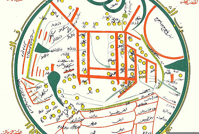
Figure 14. World map from Mahmud el-Kashgari’s Diwan, 11th century (Source)

Mahmûd bin Hüseyin bin Muhammed El Kaşgari was originaly from Barskhan, which today, is in the country of Kyrgyzstan. Alhough El Kaşgari is believed to have been an Muslim Scholar, his recognised speciality was in the field of linguistics, specifically in Turkic Dialects. His extensive travels throughout central Asia exposed him to the varying spoken Turkic dialects and caused him to compose his most prestigious work, Divanu lugat it-Türk.[28]

In his world map from the Divanu lugat it-Türk, El Kaşgari intricately depicts the locations of different Turkic tribes from Europe all the way through to China. The map reveals just how diverse the Turkik speaking people really are and the extent to which they travelled across the world. Prof Sevim Tekeli has mentioned in her article “This book was written in order to teach the Arabs Turkish and to prove that the Turkish language was as important as Arabic.”[29] Today only one copy remains of the Divan, dating back to the 13th century by al-Sâvî, a Persian polymath who claims he copied the Divan from the original manuscript.[30]

This map is unique as it is colour and shape coded for distinguishing different aspects. For example, the Turkish tribes in this map are marked and represented by yellow dots. El Kaşgari’s map is set apart from other maps of this period due to the fact that it focuses on mapping the locations of different tribes and their languages. Although this map may not be a typical map used for navigation it surely is a unique piece of early linguistic thought.[31]

Today, the Divanu lugat it-Türk is a priceless document for the linguistic and anthropological study of Inner Asia’s Turkic populations in Qarakhanid times.” Svat Soucek[32]

***

7. Al-Idrisi’s World Map, 12th Century


Figure 15. Al-Idrisi’s 12th century world map (Source)

One of the most remarkable products or medieval mapmaking…
…Perhaps the most striking feature is its orientation: south is at the top.” Jerry Brotton[33]

Abu Abdullah Muhammad al-Idrisi al-Qurtubi al-Hasani as-Sabti, or simply Al-Idrisi, was a well-known 12th century Muslim geographer, cartographer and Egyptologist. He is responsible for one of the most famous maps appearing in the history of Muslim civilisation. Born in Ceuta, Morocco, he later moved to Palermo, Sicily.  

Al-Idrisi was a distinguished guest of the Sicilian Monarch Roger II, and spent much of his working life in Sicily. After completing his studies in Córdoba, he went on to travel extensively throughout the Mediterranean from Lisbon to Damascus. It was Roger II who had requested a group of geographers, with Al-Idrisi as the permanent secretary, to collate all available resources and compose an accurate world map. Of the twelve scholars commissioned to this cartographic project, ten of them were of the Muslim civilisation. The research required for this map took fifteen years after which the actual map making process began. This resulted in the creation of Kitab nuzhat al-mushtaq fiikhtiraq al-afaq (Entertainment for He Who Longs to Travel the World”). The manuscript consists of 70 maps with its world map featured first in the collection. Al-Idrisi’s maps are some of the most mimetic works of the Middle Ages. His maps also portray a detailed grasp of the topography of the Mediterranean region.[34]


Figure 16. The original world map by al-Idrisi. On the left, shows how the map is supposed to be viewed with Makkah (Mecca) centred north of Arabia. On the right, the map has been flipped upside-down to show the modern approach when viewing the world map (Source)

***

8. al-Qazwini Map, 13th Century


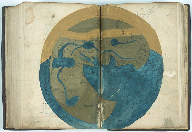
Figure 17. Al-Qazwini’s world map of the inhabited world, from cosmography (Source)

Zakariya Ibn Muhammad al-Qazwini (1203-1283) was a Persian encyclopaedist known for his treatise on cosmography, Kitab ‘aja’ib al-makhluqat wa-ghara’ib al-mawjudat (Marvels of things created and miraculous aspects of things existing) and his geographical work, Athar al-bilad (Monuments of the lands). Both of these works were composed in Arabic and included maps of the world and of his hometown in Persia, the ancient city of Qazwin.

His maps follow the standard Muslim tradition portraying the southern parts of the world at the top. Interestingly he depicts the Indian Ocean to be enclosed by a section of Africa. This idea is thought to have been derived from Ptolemy. His world map (above) is decorated with gold leaf and silver, making this map one of the more aesthetic works from Muslim civilisation. This map is not only aesthetically beautiful, but also very informative as it even represents the seven climate zones, signified by paralleled red lines.

Best known of this genre [‘aja’ib or wondrous literary tradition of mapping] is the work of the thirteenth-century Iranian writer Zakariya ibn Muhammad ibn Mahmud Abu Yahya al-Qazwini, whose work ‘Aja’ib al-makhluqat wa-ghara’ib al-mawjudat (The Wonders of Creatures and the Marvels of Creation) focuses on the wonders of the world – real and imaginary.” Karen C. Pinto[35]

  
Figures 18-20. left: 16th century copy of Al-Qazwini’s world map from his “Marvels of Regions” (Source), centre: 15th century version of Al-Qazwini’s world map, oriented with South at the top (Source), right: 14th century copy of Al-Qazwini’s zonal world map from his Athar-al Bilad wa Akhbar al Ibad (Source)

***

9. Ibn al-Wardi Map, 14th Century


Figure 21. Ibn al-Wardi World Map 1001 AD orientated with south at the top (Source)

…it’s darkness [Bahr al-Muhit-Atlantic Ocean] is caused by the great distance from the place of sunrise and sunset… A sea to which no coast is known. Its depths are not known to anyone but God.” Ibn al-Wardi[36]

Abū Ḥafs Zayn al-Dīn ʻUmar ibn al-Muẓaffar Ibn al-Wardī, also known as Ibn al-Wardi, was a 13th century Arabian historian. His most notable work is the book entitled, Kharîdat al-‘Ajâ’ib wa farîdat al-gharâib, or The Pearl of Wonders and the Uniqueness of Strange Things. This book contained one of his world maps and also included a picture of the Kaaba. Differentiating aspects such as climate, terrain, flora and fauna, population, lifestyle, states and government, Ibn al-Wardi describes in detail the characteristics of the Muslim World of that time. His depictions of the Nile are shockingly accurate as well as the boundary lines drawn to distinguish different counties.  

The first of a series of maps by Ibn al-Wardi is found in a genealogical manuscript called the Cream of Histories, Zübdetü’t-tevarih, by Seyyid Loqman ibn Hüseyin ibn el-’Asuri el-Urmevi.

   
Figures 22-25. A copy of Ibn al-Wardi’s world map (Source), $140,000 Girard-Perregaux watch with al-Wardi’s map (Source), a copy of al-Wardi’s world map (Source) and a Czech National Library copy of al-Wardi’s map, MS XVIII (Source)   

***

10. Piri Reis Map, 16th Century


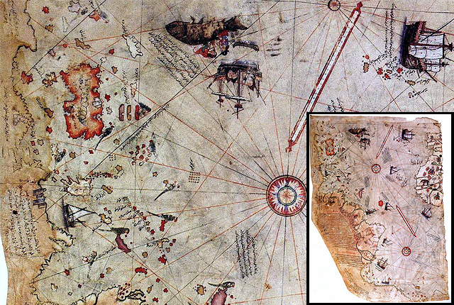
Figure 26. Piri Reis’s World map, 16th century (Source)

The Piri Reis map of 1513 is one of the most beautiful, most interesting, and most mysterious maps to have survived the Great Age of Discoveries. Yet it is one of the least understood maps of this momentous and remarkable period in the history of cartography and geographic explorations.” Gregory C. McIntosh[37]

One of the most controversial and enigmatic maps in the history of cartography…” Norman J. W. Thrower[38]

Piri Reis is perhaps the most well-known Ottoman-Turkish cartographer and admiral from the 16th century. His famous world map compiled in 1513 and discovered in 1929 at Topkapi Palace in Istanbul, is the oldest known map showing the Americas. Despite being the earliest map showing the New World, it is also subjected to controversy according to some scholars.[39] His map is unique in the sense that it has drawn the attention of both mainstream and alternative scholars.

Piri Reis composed this map by using around twenty other maps from the likes of Columbus and some maps thought to have been passed down from Alexander the Great. Another thought-provoking feature of this map is that it accurately depicts the Antarctic continent attached to South America and interestingly reveals a section of the Antarctic continent without ice, which according to Captain Lorenzo W. Burroughs, a U.S. Air Force captain, is surprisingly accurate. More rational and conservative scholars suggest that these mysterious depictions are mere inaccuracies, a commonality in the cartographic traditions of that time.

   
Figures 27-30. Piri Reis’ depiction of the Mediteranean (Source), Cyprus (Source), Venice (Source), Granada/Spain and its surrounding areas (Source)

***

11. Ali Macar Map, 16th century


Figure 31. Ali Macar’s world map (Source)

The “Ali Macar Reis Atlas” is housed in the Topkapi Palace Museum Library in Istanbul. As a work of art, this atlas certainly ranks among the most successful. Composed in 1567, they are drawn on parchment leaves and bound in leather, forming an appealing small volume.

The artist-cartographer who drew these charts must have been professionally connected to those who drew other similar maps in Europe; and the perfection of this atlas strongly argues against it being the isolated work of a captain who would only have been imitating such models; the author must have been a craftsman with a sound grasp of cartographic know-how.

As Macar means Hungarian in Turkish, it seems that its [‘Ali Macar Reis atlas] author, ‘Ali Macar, was in fact a Hungarian geographer working for the Ottoman authorities, whose charts drew on his experience of both Ottoman and European regions to create a comprehensive atlas focused primarily on the Mediterranean.” Jerry Brotton[40]

***

12. Tarih-i Hind-i Garbi Map, 16th century


Figure 32. Tarih-i Hind-i Garbi map, 16th Century (Source)

The book entitled Tārih-i Hind-i Garbī (History of the West Indies), probably written by Muhammad b. Amir al-Suûdī al-Niksarī (d. 1591) in the 16th century, contains information about geographical discoveries and the New World (America). This work, based on Spanish and Italian geographical sources, was presented to Sultan Murād III in 1573.

The book tells many amazing stories of the explorations and conquests of Columbus, Cortes, Pizarro, and others, and it also endeavours to incorporate the new geographic information into the body of Islamic knowledge. It presents a major effort from an Ottoman Muslim scholar. It is quite unique for the 16th century; firstly, in transmitting by translation, information from one culture (European Christendom) to another (Ottoman Islam), and secondly, to correct and expand Islamic geography and cartography.

One of the major attractions of the Tarih-i Hind-i garbi is the visual material that many of its copies contain. Some of the manuscripts are illustrated with maps including the American continent…
…Of special interest is the anonymous author of the Tarih-i Hind-i garbi, or ‘history of the western Indies’, who hoped to encourage the Sultan of his time, presumably Selim II and/or Murad III to conquer at least a part of this remote continent [meaning West Indies].” Suraiya Faroqhi[41]

***

13. Kâtip Çelebi Map, 17th century


Figure 33. Kâtip Çelebi World Map (Source)

Tuhfat Al-Kibâr fî Asfâr Al-Bihâr (The Gift to the Great Ones on Naval Campaigns) was written by Kâtib Çelebi in 1657 and emphasises the importance of the [Ottoman] activities in the seas and the Ottoman contribution to navigational history.

Kâtib Çelebi emphasised the importance of science in geography in the introduction of Tuhfat al-kibâr. He explained that the rulers of the state should know the frontiers and borders of the Ottoman State and the states in this region even if they do not know the whole of the Earth.

Katip Çelebi was clearly aiming at educating the Ottoman court and helping to formulate its imperial policies. But his work definitely found a larger audience both within and outside the Ottoman Empire in the following centuries.” Pinar Emiralioglu[42]

Çelebi valued history and asserted that most people overlook the value of this branch of knowledge and thus viewed history as if it were a tale. He expressed his complaint about this saying “who reads and listens to a letter of love and faithfulness?“.


Figure 34. another World Map, Müteferrika edition of Tuhfat al-Kibar (Source)

***

14. Erzurumlu Ibrahim Hakki Map, 18th Century


Figure 35. Erzurumlu Ibrahim Hakki’s World Map in his Marifetname book (Source)

Ibrahim Hakkı Erzurumi was born 18 May 1703 and died on 22 June 1780. He was an internationally renowned Turkish Sufi, philosopher and encyclopaedist.[43] He published his work Marifetname (Book of Gnosis) in 1756. It was a compilation and commentary on astronomy, mathematics, anatomy, psychology, philosophy, and mysticism. It is known for containing the first treatment of post-Copernican astronomy by a Muslim scholar. 

Ibrahim Hakki would commonly incorporate latitude and longitudinal lines in his maps, where he used the district of Tillo as ground zero. He also presumed that the Earth was geodic in shape and reveals this in a globe which he built with slightly flattened poles to point out that the Earth is not perfectly spherical. Atomic structures, gravity and the Earth’s atmosphere and hydrosphere were other subject areas he touched upon. 

His book Marifetname, similar to an encyclopaedia, is a work that encompasses diverse subjects and many areas; religion, literature, Sufism, geography, history, cosmography, biology, fashion, and much, much more.” Şefik Can[44]

***

15. Appendix I – Other Maps

Here are some other maps that do not fit the description of ‘World maps’, but are worthwhile mentioning:

15.1 Taqwim-I ta’rikhi (Historical Calendar), 15th Century


Figure 36. Taqwim-I ta’rikhi, this map dates back to time of Murad II, 15th Century. Courtesy: The Chester Beatty Library, Dublin (Source)

This map, Taqwim-I ta’rikhi (Historical Calendar), is possibly the oldest existent Ottoman map. Interestingly, this map, as well as the other Ottoman maps, do not follow the typical medieval al-Balkhi or al-Istakhri cartographic tradition. The Ottomans were not familiar with these cartographic schools, rather, they drew their influence from a manuscript gifted to them from the east. This manuscript is still in existence and located in the Topkapi Saray Library in Istanbul, Ahmet 2830.[45]

***

15.2 Matrakci Map, 16th Century


Figure 37. City of Istanbul and Develi illumination from Matrakçi’s Beyân-i Menâzil-i Sefer-i ‘Irakeyn (Source)

This aesthetic map would have been included in the list above, however Matrakci’s maps were designed for the single purpose of mapping cities and marking the locations of important civic buildings. Matrakci Nasuh was a famous Ottoman polymath, writer and knight who produced important books in several fields. He made contributions in the fields of mathematics, geography, history and calligraphy. Although little is known about Matrakci, he is thought to be of Bosnian origin because of his name. Although most of Matrakci’s works are considered to be pieces of art, some of his painting fall under the category of cartography because of their accuracy in depicting city roads, infrastructure and buildings.[46]  

The idea of incorporating topographic imagery into the illustrated manuscript tradition was carried even farther by Matrakci Nasuh who, upon commission of Suleyman, produced the lavishly illustrated Beyan-i Menazil in 1537 to commemorate Suleyman’s 1534-35 campain to the eastern frontier…” Bruce Alan Masters[47]

Read More

  • Muslim HeritageNasuh Al-Matrakci, A Noteworthy Ottoman Artist-Mathmetician of the Sixteenth Century, by Salim Ayduz
  • MatrakciNasuh.com: MATRAKÇI NASUH ‘’Nasuh bin Karagöz bin Abdullah el Bosnavi’’, by Beste Gürsu

  
Figures 38-40. Matrakci’s Baghdad, Tebriz, Diyarbakir

***

15.3 Al-Rudani’ Astrolobe 17th Century


Figure 41. Al-Rudani astrolabe, 17th century (Source)

Abū ʿAbdallāh Muḥammad ibn Sulaymān (Muḥammad) alFāsī ibn Ṭāhir alRudānī alSūsī alMālikī [alMaghribī], better known as al-Rudani, was a 17th century astronomer and scholar who was born in Morocco and died in Syria. He was known as a poet, mathematician, Hadith specialist, Quran Interpreter and an Arabic Grammar specialist.  

The image above is one of only three known Al-Rudani spherical astrolabes. Sold at an auction for close to $1 million[48], the astrolabe was beautifully made by the 17th century astronomer who put his inscription on the surface of the sphere in Medina. Known for his work on astronomical instruments, Al-Rudani, was also a poet and wrote on mathematics and grammar.

Read More

  • McGill UniversityRudānī: Abū ʿAbdallāh Muḥammad ibn Sulaymān (Muḥammad) al‐Fāsī ibn Ṭāhir al‐Rudānī al‐Sūsī al‐Mālikī [al‐Maghribī], by Salim Ayduz

***

16. Appendix II – Further Contributions

It was during the Abbasid Caliphate when Muslim Civilisation was said to have reached its peak. The Caliphs commissioned reports on roads to help their postmasters deliver messages to addresses within their empire. These accounts which initially resulted in the Book of Routes, laid the foundation for more intensive information gathering about far-away places and foreign lands with their physical landscape, production capabilities and commercial activities. With the development of more accurate astronomy and mathematics, map plotting became a respected branch of science.

Geography became an important field of study especially with the work of Al-Khwarizmi, one of the earliest scientific descriptive geographers and a highly talented mathematician. His famous book, The Form of the Earth, inspired a generation of writers in Baghdad and Muslim Spain (Al-Andalus). It became a major source of inspiration to unearth, analyse and record geographical data among many well-known scholars after him.

There are many more names that contributed to the geography field from Muslim Civilisation to the Modern World such as:

  • al-Muqaddisiborn in 946 CE, was a medieval Arab geographer from Jerusalem. He had a privileged education and travelled throughout much of the Muslim world. In 985 CE, he settled down to write his book Aḥsan al-taqāsim fī maʿrifat al-aqālīm (The Best Divisions in the Knowledge of the Regions). His book gives us a detailed account of the different regions and places in which he spent time.
  • Al-Razi, known in Europe as Rhazes. He compiled a basic geography of the Iberian Peninsula
  • Mohammed Ibn Yousef Al-Warraq committed to paper the topography of North Africa. 
  • Al-Bakri who was an accomplished scholar and litterateur, wrote an important geographical work devoted to the Arabian Peninsula and the names of various places.
  • Ibn Baitar of Malaga was driven by his genuine interest in pharmaceutical herbs and flowers to explore every nook and cranny of the Iberian Peninsula and the Maghreb (Morocco).
  • Ibn Khaldun, a Tunisian adventurer, university professor and diplomat, is known for his works of sociology, economics, commerce, history, philosophy, political science and anthropology. He wrote his famous History of the World during a period of enforced exile. 
  • Ahmad ibn Majid, a poet and a navigator, also known for assisting Vasco da Gama in his quest of South Africa and for his Book of Useful Information on the Principles and Rules of Navigation.
  • In addition to other travellers like famous Ibn Battuta, Ahmad ibn Fadlan, Ibn Jubair, Zheng He or other know or unknown geographers from different backgrounds such as Miskawayh, Ibn Rustahal-Tartushi, Ahmad al-Ya’qubi, Ibn Qutiya, al-Maqqari, Ibn al-Athir, Yaqut al-Hamawi, Abu al-Fidaand, ibn Abi Bakr al-Zuhari and many more…

Read More

  • Related Muslim Heritage Articles (Link)

***

17. Further Reading (Bibliography) 

  • #212, Masudi. [online] Available at: http://cartographic-images.net/Cartographic_Images/212_Masudi.html. [28/11/17].
  • Abattouy, M. The Book of Curiosities or A Medieval Islamic View of the Cosmos. [online] Available at: http://www.muslimheritage.com/article/book-curiosities-or-medieval-islamic-view-cosmos. [28/11/17].
  • Abdul Jabbar Beg, M. The Origins of Islamic Science. [online] Available at: http://www.muslimheritage.com/article/origins-islamic-science. [28/11/17].
  • Ahmed, N. Al Masudi. [online] Available at: https://historyofislam.com/contents/the-classical-period/al-masudi/. [28/11/17].
  • Aj’ib al-makhluquat [The Marvels of Created Things]. [online] Available at: http://cartographic-images.net/Cartographic_Images/222_al-Qazwini.html. [28/11/17].
  • Antrim, Z. (2012). Routes and Realms: The Power of Place in the Early Islamic World. Oxford University Press.
  • Ayduz, S. Ottoman Contributions to Science and Technology. [online] Available at: http://www.muslimheritage.com/article/ottoman-contributions-science-and-technology. [28/11/17].
  • Ayyubi, A. Contribution of Al-Khwarizmi to Mathematics and Geography. [online] Available at: http://www.muslimheritage.com/article/contribution-al-khwarizmi-mathematics-and-geography. [28/11/17].
  • Balkhi World Map. [online] Available at: http://cartographic-images.net/Cartographic_Images/214.2_Balkhi.html [28/11/17].
  • Brotton, J. (2014). Great Maps: the World’s Masterpieces Explored and Explained. London: Dorling Kindersley.
  • Brotton, J. (1997). Trading Territories: Mapping the Early Modern World. Reaktion Books.
  • Emiralioglu P. (2016). Geographical Knowledge and Imperial Culture in the Early Modern Ottoman Empire. Routledge.
  • Ibn Hawqal. [online] Available at: http://www.muslimheritage.com/scholars/ibn-hawqal. [28/11/17].
  • Maclsaac, T. Piri Reis Map: Evidence of a Very Advanced Prehistoric Civilization? [online] Available at: http://www.theepochtimes.com/n3/1165572-piri-reis-map-evidence-of-a-very-advanced-prehistoric-civilization/. [28/11/17].
  • Al-Masudi. [online] Available at: http://www.muslimheritage.com/scholars/al-masudi. [28/11/17].
  • McIntosh, G.C. (2012). Piri Reis Map of 1513. University of Georgia Press.  
  • Nizamoglu, C. Nearly 3 Centuries old light system illuminates a sacred grave on Sun’s equinox. [online] Available at: http://muslimheritage.com/article/light-refraction-mechanism. [28/11/17].
  • Ozturk, R. and Ayduz, S. A Jewel of Ottoman Naval History: The book of Katib Çelebi on Naval Campaigns. [online] Available at: http://muslimheritage.com/article/jewel-ottoman-naval-history-book-k%C3%A2tib-%C3%A7elebi-naval-campaigns. [28/11/17].
  • Pinto, K.C. (2016). Medieval Islamic Maps: An Exploration. Chicago/London: The University of Chicago Press.
  • Park, H. (2012). Mapping the Chinese and Islamic Worlds: Cross-Cultural Exchange in Pre-Modern Asia. Cambridge University Press.
  • Rapoport, Y. and Savage-Smith, E. (2013). An Eleventh-century Egyptian Guide to the Universe: The Book of Curiosities. Brill.
  • Sayyid, A.F. The Unpublished Works of Arabic Geography: An Overview and a Classification. [online] Available at: http://www.muslimheritage.com/article/unpublished-works-of-arabic-geography. [28/11/17].
  • Tekeli, S. The Oldest Map of Japan Drawn by Mahmud of Kashgar. [online] Available at: http://www.muslimheritage.com/article/oldest-map-japan-drawn-mahmud-kashgar. [28/11/17].
  • The Book of Curiosities. [online] Available at: http://cosmos.bodley.ox.ac.uk/hms/home.php. [28/11/17].
  • World Map of Ibn Hawqal. [online] Available at: http://cartographic-images.net/Cartographic_Images/213_Ibn_Hawqal.html. [29/11/17].
  • World Maps of Al-Idrisi. [online] Available at: http://cartographic-images.net/Cartographic_Images/219_al-Idrisi.html. [28/11/17].
  • World Map of al-Istakhri. [online] Available at: http://cartographic-images.net/Cartographic_Images/211_al-Istakhri.html. [28/11/17].
  • World Map of al-Kashghari. [online] Available at: http://cartographic-images.net/Cartographic_Images/214_al-Kashghari.html. [28/11/17].
  • World Map of al-Wardi. [online] Available at: http://cartographic-images.net/Cartographic_Images/214.1_al-Wardi.html. [28/11/17].
  • Tillo: The Wisdom That Catches the Sun. [online] Available at: http://www.skylife.com/en/2009-09/tillo-the-wisdom-that-catches-the-sun. [28/11/17].
  • Zaimeche, S. History, Culture and Science in Morocco: 11th-14th Centuries. [online] Available at: http://www.muslimheritage.com/node/632#sec4. [28/11/17].
  • Zaimeche, S. Piri Reis: A Genius 16th-Century Ottoman Cartographer and Navigator. [online] Available at: http://www.muslimheritage.com/article/piri-reis-genius-16th-century-ottoman-cartographer-and-navigator. [28/11/17].

***

To put a city in a book, to put the world on one sheet of paper — maps are the most condensed humanized spaces of all…They make the landscape fit indoors, make us masters of sights we can’t see and spaces we can’t cover.” Robert Harbison[49]